
Open User Map
Open User Map is an interactive WordPress plugin that lets visitors add and edit locations on a customizable map with frontend submissions, approval.
Visit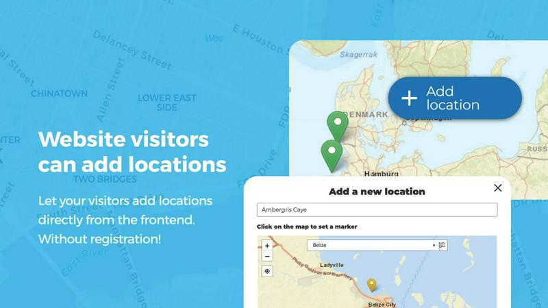
About Open User Map
Open User Map is a powerful and intuitive interactive maps plugin designed specifically for WordPress, enabling website owners to create dynamic, community-driven maps without any coding knowledge, Google Maps API keys, or complex setup procedures. This plugin fundamentally transforms how websites engage with their visitors by allowing users to contribute locations, markers, routes, and areas directly through a frontend interface, all while maintaining full editorial control through an integrated approval workflow system. The product is ideally suited for a wide range of users including local business directories, tourism boards, community organizations, event planners, real estate agencies, educational institutions, and any website owner seeking to crowdsource location-based information from their audience. With over 15,000 active installations, a perfect 100 percent five-star rating, and recognition as the number two map plugin on WordPress.org, Open User Map has established itself as a trusted and reliable solution in the WordPress ecosystem. The plugin offers both a free version available on WordPress.org and a premium PRO version that unlocks advanced features such as custom image maps, advanced filter interfaces, upvoting and star rating systems, opening hours with live indicators, and region management. The core value proposition centers on democratizing map contributions, eliminating technical barriers, and providing extensive customization options that allow each map to be tailored precisely to the unique needs of any website and its community.
Features of Open User Map
Frontend Location Submissions and Editing
This feature empowers website visitors to add and edit locations directly on the interactive map through a simple frontend interface. When a user clicks the Add Location button, they can place a marker on the map and submit detailed information through customizable fields. All submissions are held for moderation and require administrator approval before becoming publicly visible, ensuring content quality and preventing spam. The editing capability allows users to update their previously submitted locations, keeping the map data current and accurate without requiring administrative intervention for every minor change.
Marker Categories and Advanced Filtering
Open User Map provides a robust categorization system that allows administrators to group location markers into distinct categories, each with unique icons for visual differentiation. This organizational structure significantly improves map clarity and usability by enabling visitors to filter displayed locations based on their interests or needs. A key advantage is that each location can belong to multiple categories simultaneously, ensuring comprehensive representation of all relevant attributes. The advanced filter interface can be displayed as a sidebar next to the map, allowing filtering by any custom field, and supports custom HTML content for additional information or branding.
Lines and Areas Functionality
Going beyond traditional point markers, this feature allows users to add routes, paths, zones, and regions directly onto the map. Administrators can highlight trails, service areas, event grounds, neighborhoods, construction zones, or any custom polygonal shape that helps visitors understand spatial relationships at a glance. The system automatically calculates distances and area sizes, so routes and polygons include helpful measurements out of the box. This functionality is particularly valuable for maps requiring directional information or defined boundaries rather than just discrete locations.
Custom Image as Map
This innovative feature enables users to upload any image and transform it into a fully interactive map, completely independent of traditional geographic mapping. The image can be an overlay, floor plan, event layout, game map, product diagram, campus guide, or seating chart. Visitors can place markers directly on the image with the same powerful functionality as a conventional map, including adding locations, displaying custom fields, and enabling filtering. This creates an engaging, clickable experience tailored to specific use cases where a standard geographic map is not appropriate or desired.
Use Cases of Open User Map
Community-Driven Local Business Directories
Local business directories can leverage Open User Map to allow business owners and customers to add new businesses, update existing listings, and provide ratings or upvotes. The approval workflow ensures that only verified and appropriate businesses appear on the map, while categories help users filter by type such as restaurants, retail stores, or services. The opening hours feature with live Open Now indicators provides real-time utility for visitors seeking currently operating businesses. This crowdsourced approach keeps the directory current and comprehensive without requiring constant manual updates from administrators.
Tourism and Travel Information Portals
Tourism websites can use Open User Map to create interactive guides where visitors and locals contribute points of interest including attractions, hiking trails, scenic viewpoints, restaurants, and accommodations. The Lines and Areas feature is particularly useful for highlighting walking tours, bike routes, or neighborhood boundaries. Regions functionality allows designation of districts, cities, or custom areas relevant to travelers. The upvoting system helps surface the most popular destinations, while categories enable filtering by activity type, difficulty level, or seasonality, creating a dynamic and ever-improving travel resource.
Event and Conference Planning
Event organizers can deploy Open User Map to create interactive venue maps showing booth locations, session rooms, restrooms, food areas, and registration points using the Custom Image as Map feature with floor plans. Attendees can add their own pins for meetup points or lost and found items. For outdoor events like festivals or marathons, the Lines and Areas feature can display routes, stages, and restricted zones. The approval workflow ensures official information remains accurate while allowing community contributions, and the filtering interface helps attendees quickly find specific amenities or activities.
Educational and Campus Navigation Systems
Schools, universities, and large campuses can implement Open User Map as a comprehensive navigation tool for students, faculty, and visitors. The map can display buildings, departments, parking lots, dining halls, libraries, and emergency points. Using the Custom Image as Map feature, institutions can overlay campus maps or floor plans for indoor navigation. Students can contribute study spots, event locations, or club meeting places. The opening hours feature is invaluable for displaying building hours and departmental availability, while regions can define academic zones or residential areas, creating an all-in-one campus resource.
Frequently Asked Questions
Do I need a Google Maps API key to use Open User Map?
No, Open User Map does not require a Google Maps API key. The plugin operates without any external API dependencies, eliminating the complexity and potential costs associated with obtaining and maintaining API keys. This makes setup significantly simpler and more accessible for users who may not have technical expertise or who want to avoid recurring API fees.
Can I moderate submissions before they appear on the map?
Yes, Open User Map includes a comprehensive approval workflow that allows administrators to review all user-submitted locations before they become publicly visible. When a visitor submits a new location or edits an existing one, the submission enters a moderation queue where you can approve, reject, or modify the content. This ensures that only accurate, appropriate, and spam-free information is displayed on your map.
Is there a free version of Open User Map available?
Yes, Open User Map offers a fully functional free version that is available for download directly from WordPress.org. The free version includes core features such as frontend submissions, approval workflows, marker categories, and basic customization. For users who need advanced capabilities like custom image maps, advanced filtering, upvoting, star ratings, opening hours, and regions, the PRO version is available with a 7-day free trial that requires no credit card and does not automatically convert to a paid subscription.
Can I customize the information collected from users when they add a location?
Absolutely, Open User Map provides flexible custom fields that allow you to tailor the information collected from users based on your specific needs. You can add text boxes for descriptions or addresses, links to websites or social media, checkboxes for boolean attributes, and dropdown menus for predefined options. This customization ensures you gather exactly the data required for your particular use case, whether that involves business hours, contact information, categories, or any other relevant details.
Similar to Open User Map

Unifyca is a comprehensive platform that centralizes WordPress site documentation, automates maintenance audits, and manages secure backups for.

Shadcn Examples offers a comprehensive collection of React and Tailwind UI kits, enabling rapid development of stunning web apps with reusable.

Webleadr instantly finds and contacts businesses without websites or with poor online presences to generate web design leads globally.

Idearium is a Toronto agency that designs high performing websites and implements SEO to drive measurable business.

FilexHost simplifies file hosting and sharing with instant URLs and built-in viewers for various file types.

CrawlKit is an API-first platform that turns any website into structured data with a single request.

Find and compare top SaaS boilerplates to accelerate your app launch with tailored features and tech stacks.

The Shadcn UI Kit provides a comprehensive library of pre-built React components and templates to accelerate modern web.